flak monkey
|
| posted on 2/10/05 at 05:38 PM |

|
|
Google Earth
Not sure if anyone has seen this yet.
Google have their own world explorer type program that lets you zoom to anywhere in the world. Some places are very detailed indeed (like the grand
canyon and other major sites).
Theres a screen shot below. Pretty awesome.
Go to google and type in google earth to get the link to download it. Free and only about 12Mb.
David 
 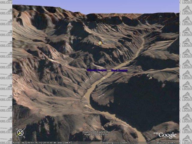
Rescued attachment grand canyon.jpg
Sera
http://www.motosera.com
|
|
|
|
|
David Jenkins
|
| posted on 2/10/05 at 07:19 PM |
|
|
And if you type in a UK postcode it will zoom in and show you where you live...
|
|
|
RI8CHP
|
| posted on 2/10/05 at 07:39 PM |
|
|
yeah you can enter any uk post code and have a look its not very clear untill you reg for the full version though
|
|
|
macspeedy
|
| posted on 2/10/05 at 07:45 PM |
|
|
there is this as well which is cool
http://www.googleearthhacks.com/
|
|
|
David Jenkins
|
| posted on 2/10/05 at 09:03 PM |
|
|
quote:
Originally posted by RI8CHP
yeah you can enter any uk post code and have a look its not very clear untill you reg for the full version though
Depends where you live - my house is out in the sticks so there isn't much detail.
However, London buildings can be seen in a fair bit of detail, and my parents' house on the outskirts of Swansea is also clearly visible (I can
see that his car wasn't in the drive when the satellite went over!)
David
[Edited on 2/10/05 by David Jenkins]
|
|
|
steve_gus
|
| posted on 2/10/05 at 09:05 PM |
|
|
multimap has an aerial photo feature. However, they have modified it recently so that you cannot zoom in much - you have to buy the pics. Before they
restricted it, you could see individual houses
atb
steve
http://www.locostbuilder.co.uk
Just knock off the 's'!
|
|
|
skydivepaul
|
| posted on 2/10/05 at 09:40 PM |
|
|
Pretty cool
has a lot more detail in the USA than in england
http://www.smartideasuk.com
http://www.smartmapping.co.uk
HD CCTV
3D design solutions and integration
IP security systems
access control systems
|
|
|
JoelP
|
| posted on 2/10/05 at 10:01 PM |
|
|
i got bored of it due to a lack of detail, and also too many scenes were taken at an angle. Overhead view would be better throughout. Maybe improve
with time...
Beware! Bourettes is binfectious.
|
|
|
Hellfire
|
| posted on 2/10/05 at 10:13 PM |
|
|
I too got bored of it due to lack of detail (on the free version) although I believe that if you pay for the full version, you do get greater detail.
Its pretty pointless though, other than to highlight what modern technology is/will eventually be capable of. 

|
|
|